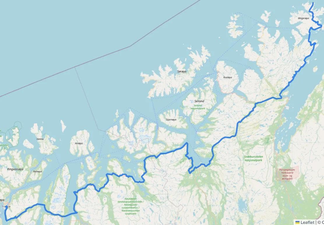
Finnmark
549.71 km
4781 m
National Cycle Route 1, North Cape - Tromsø
Here you will find the GPX file for the National Cycle Route 1 (Kystruta) from Nordkapp to Tromsø
We have not yet certified and described this route, as our route mappers have not mapped this stretch. We therefore lack sufficient information about safety, signage, ferries, tunnels and other infrastructure to be able to recommend this route as optimal. However, to give you easy access to the GPS track on the route, we have chosen to post the GPX file on SykkelNorge.no. It can be used as a good starting point for planning your cycling trip in the area.
We recommend loading the GPX file into a digital mapping platform to plan your trip in detail. Ride With GPS is a platform used by the Cyclists’ Association. If you’re going on a long bike ride, it’s well worth spending some time learning how to use this service to easily plan your trip in detail. It will probably provide an even better travelling experience.
The Norwegian Public Roads Administration (Statens Veivesen) is responsible for the National Cycle Routes with regard to routing and signposting.
This is what the Norwegian Public Roads Administration writes about the route:
«The North Cape is often the starting or ending point of a ‘Norway along’ cycle tour. The northernmost part of such a trip is also the roughest, but in fine weather it’s hard to imagine touring cycling getting any better than this. In Alta you can visit the rock art, which is Northern Europe’s largest collection of rock carvings and a UNESCO World Heritage Site.
Much of the 550-kilometre route from the North Cape to Tromsø offers beautiful views of fjords and mountains. Vegetation is sparse, especially in the north. Due to the large, open landscapes, it’s a good idea to check the wind direction and strength. The Kvænangsfjellet and Sennalandet mountain passes and the road along the Porsangerfjord in the north are particularly vulnerable.
The entire route is paved and mainly follows the E6 and E69 motorways, except in a few places where it follows quiet county roads and ferries through Lyngen. A little car traffic is to be expected, especially near the towns on the route. You’ll also have to cycle through the 6.9-kilometre Nordkapp tunnel, where the lowest point is 212 metres below sea level.
In some places along the route, it’s a long way to the next opportunity to buy food.